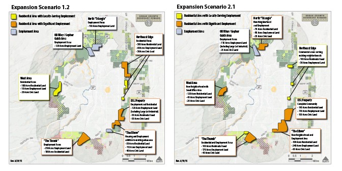
The steering committee for the City’s Urban Growth Boundary (UGB) Remand project recently approved three alternative UGB expansion alternatives, or “scenarios,” for further evaluation.
The UGB is a line on the City’s map that represents an estimated 20-year supply of land for housing, employment and other urban uses. The City is leading an extensive public process to develop a UGB expansion plan that reflects the community’s values and meets state planning requirements.
The steering committee recently affirmed or refined expansion scenario recommendations from the project’s Boundary and Growth Scenarios Technical Advisory Committee (Boundary TAC). The approved scenarios result from: significant evaluations by City staff, consultants and Boundary TAC regarding the suitability of different areas surrounding the city for future growth and development; a public workshop to generate ideas for where needed land uses should be accommodated and Boundary TAC input on draft scenarios.
Each of the three UGB boundary scenarios assumes the City would add approximately 2,000 acres of land to the UGB to meet housing, employment and other land needs. Expansion is targeted to those areas that have been identified as relatively better suited to meeting state requirements and local goals for future growth. Each scenario includes expansion in multiple directions. See maps in attached document for details.
All of the scenarios include areas that would become “complete communities” with a mix of housing, jobs and services, as well as areas that would allow for housing and employment development at a smaller scale. The scenarios are also designed to be compatible with adjacent areas within the existing UGB.
The steering committee also approved a recommendation by the Boundary TAC to further analyze land identified as suitable for UGB expansion but not included in the three scenarios. These “supplemental analysis areas” could be included in the UGB at a future date if they appear to serve the project goals better than areas included in the three scenarios.
What’s next? During the next several months, the project’s consultant team will evaluate each scenario by analyzing and balancing a set of factors as required by state law:
(1) efficient use of land;
(2) orderly and economic provision of public facilities and services;
(3) comparative environmental, social, economic and energy consequences; and
(4) compatibility of future urban use with nearby agricultural and forest activities outside the UGB.
Many issues will be considered as part of the evaluation. Examples include: the potential for creating walkable neighborhoods; housing affordability; costs for water, sewer and streets; wildlife impacts; wildfire risks and mitigation and compatibility with farm and forest activities.
The results of this analysis will be reviewed in the fall with the Boundary TAC, the steering committee and other community members, to identify a preferred UGB expansion area and land use plan. The preferred plan may be one of the three alternatives being studied but more likely will be a hybrid of multiple alternatives.
More information about the steering committee recommendations, background work to date, and opportunities for public involvement is available on the City’s UGB Website: www.bendoregon.gov/bendugb


